Geolocate

Sarzana topographic map

Click on the map to display elevation.

About this map

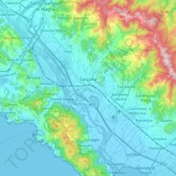
Name: Sarzana topographic map, elevation, terrain.

Location: Sarzana, Follo, La Spezia, Liguria, 19038, Italy (44.04438 9.93212 44.16939 10.02695)

Average elevation: 127 m

Minimum elevation: -4 m

Maximum elevation: 685 m

Gear up for your next adventure:

🌬️Windproof Camp Stove - Efficient cooking even on exposed mountain peaks
🚑Survival Whistle - Signal for help across long distances in mountains
🧦Outdoor Socks - Durable socks designed for hiking and outdoor sports
🧭Orienteering Kit - Tools for map reading and navigation in the wild
🧥Thermal Fleece Jacket - Versatile insulation for changing mountain temperatures

As an Amazon Associate, this site earns from qualifying purchases at no extra cost to you.