Geolocate

Reichenbach topographic map

Click on the map to display elevation.

About this map
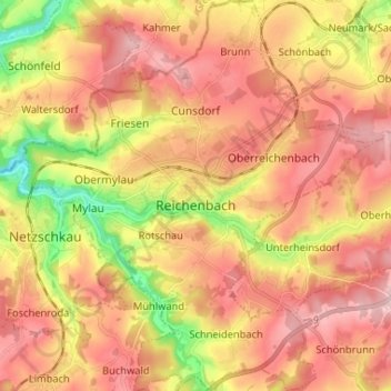
Name: Reichenbach topographic map, elevation, terrain.

Location: Reichenbach, Reichenbach im Vogtland, Vogtlandkreis, Saxony, Germany (50.58072 12.23997 50.66328 12.35857)

Average elevation: 401 m

Minimum elevation: 283 m

Maximum elevation: 482 m

Other topographic maps

Click on a map to view its topography, its elevation and its terrain.

Gippe

Germany > Saxony > Vogtlandkreis > Elsterberg

Average elevation: 358 m

Mühlleithen

Germany > Saxony > Vogtlandkreis > Klingenthal

Average elevation: 825 m

Röthenbach

Germany > Saxony > Vogtlandkreis > Bad Brambach > Hohendorf

Average elevation: 641 m

Gear up for your next adventure:

🧴Insect Repellent - Protect yourself from bugs during outdoor adventures
🔪Outdoor Multitool - Versatile tool for repairs and food prep in the wild
🗺️Topographic Maps - Detailed maps to explore trails, mountains, and wilderness areas
🥾Waterproof Hiking Shoes - Durable shoes for wet and rugged trails
⛺Bushcraft Tarp - Versatile emergency shelter or gear protection

As an Amazon Associate, this site earns from qualifying purchases at no extra cost to you.