Geolocate

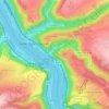
Kaub topographic map

Click on the map to display elevation.

About this map

Name: Kaub topographic map, elevation, terrain.

Location: Kaub, Loreley, Rhein-Lahn-Kreis, Rhineland-Palatinate, 56349, Germany (50.06642 7.72204 50.12315 7.83914)

Average elevation: 286 m

Minimum elevation: 67 m

Maximum elevation: 441 m

Other topographic maps

Click on a map to view its topography, its elevation and its terrain.
Gear up for your next adventure:

🧥Thermal Fleece Jacket - Versatile insulation for changing mountain temperatures
🎒Hiking Daypack - Lightweight and durable backpacks for day trips and excursions
🥾Approach Boots - Comfortable boots for hiking and climbing approaches
🏃Hydration Running Vest - Carry water and maps close to your body for speed
🥾Hiking Shoes - Durable and comfortable shoes for trail hiking

As an Amazon Associate, this site earns from qualifying purchases at no extra cost to you.