
Thank you for supporting this site ❤️
Make a donation
Make a donation
Gear up for your next adventure:
As an Amazon Associate, this site earns from qualifying purchases at no extra cost to you.
Lüsen - Luson topographic map
Click on the map to display elevation.
Thank you for supporting this site ❤️
Make a donation
Make a donation
Gear up for your next adventure:
As an Amazon Associate, this site earns from qualifying purchases at no extra cost to you.
About this map
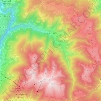
Name: Lüsen - Luson topographic map, elevation, terrain.
Average elevation: 1,647 m
Minimum elevation: 595 m
Maximum elevation: 2,573 m
Thank you for supporting this site ❤️
Make a donation
Make a donation
Gear up for your next adventure:
As an Amazon Associate, this site earns from qualifying purchases at no extra cost to you.
Other topographic maps
Click on a map to view its topography, its elevation and its terrain.
Großhorn - Corno Grande
Italy > Trentino-Alto Adige/Südtirol > South Tyrol > Graun - Curon Venosta
Average elevation: 2,295 m