Geolocate

Subukia topographic map

Click on the map to display elevation.

About this map

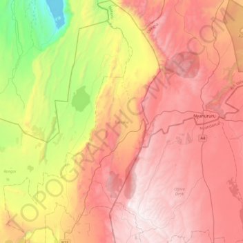
Name: Subukia topographic map, elevation, terrain.

Location: Subukia, Nakuru East, Nakuru, Rift Valley, Kenya (-0.18790 36.01764 0.23363 36.28974)

Average elevation: 2,029 m

Minimum elevation: 985 m

Maximum elevation: 2,869 m

Other topographic maps

Click on a map to view its topography, its elevation and its terrain.

Kenya

Kenya > Nakuru > Nakuru East > Nakuru East ward

Average elevation: 1,831 m

Wild Fire

Kenya > Nakuru > Naivasha > Hells Gate ward > Junction 1

Average elevation: 1,952 m

Fire

Kenya > Nakuru

Average elevation: 1,832 m

Mai Maihu

Kenya > Nakuru

Average elevation: 1,868 m

Gear up for your next adventure:

🧢Outdoor Visor - Breathable visor for sunny hikes
🥽Outdoor Goggles - Protective eyewear for outdoor activities
🧰Multitool Knife - Compact and versatile tool for outdoor use
🥾Trail Running Shoes - Lightweight and durable shoes for trail running
🥾Light Hiking Boots - Lightweight and comfortable boots for day hikes

As an Amazon Associate, this site earns from qualifying purchases at no extra cost to you.