
Make a donation
Gear up for your next adventure:
As an Amazon Associate, this site earns from qualifying purchases at no extra cost to you.
Orane/Orani topographic map
Click on the map to display elevation.
Make a donation
Gear up for your next adventure:
As an Amazon Associate, this site earns from qualifying purchases at no extra cost to you.
Orane/Orani
Orani sits at an altitude of 526 meters, at the foot of Mount Gonare, in the heart of the Barbagia region. Among the notable archaeological sites in the area are approximately 30 nuraghi and several giants' graves. The Sanctuary of Our Lady of Gonare at the crest of the mountain is of particular interest, as is the natural landscape on the road leading up to it. Orani excels in handicrafts. It is famous for its stonework, carpentry, and metalwork, and for tailors specializing in the use of traditional Sardinian velvety. The city is also home to the Nivola Museum.
Make a donation
Gear up for your next adventure:
As an Amazon Associate, this site earns from qualifying purchases at no extra cost to you.
About this map
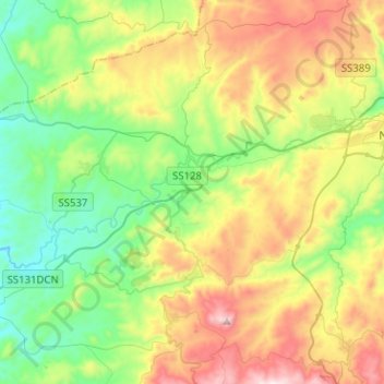
Name: Orane/Orani topographic map, elevation, terrain.
Location: Orane/Orani, Nuoro, Sardinia, 08026, Italy (40.21202 9.02626 40.37283 9.27901)
Average elevation: 505 m
Minimum elevation: 186 m
Maximum elevation: 1,072 m
Make a donation
Gear up for your next adventure:
As an Amazon Associate, this site earns from qualifying purchases at no extra cost to you.
Other topographic maps
Click on a map to view its topography, its elevation and its terrain.
Make a donation
Gear up for your next adventure:
As an Amazon Associate, this site earns from qualifying purchases at no extra cost to you.