
Thank you for supporting this site ❤️
Make a donation
Make a donation
Gear up for your next adventure:
As an Amazon Associate, this site earns from qualifying purchases at no extra cost to you.
Comasagua topographic map
Click on the map to display elevation.
Thank you for supporting this site ❤️
Make a donation
Make a donation
Gear up for your next adventure:
As an Amazon Associate, this site earns from qualifying purchases at no extra cost to you.
About this map
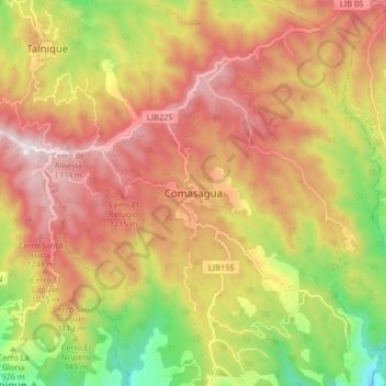
Name: Comasagua topographic map, elevation, terrain.
Location: Comasagua, La Libertad, El Salvador (13.59733 -89.41681 13.67733 -89.33681)
Average elevation: 952 m
Minimum elevation: 436 m
Maximum elevation: 1,373 m
Thank you for supporting this site ❤️
Make a donation
Make a donation
Gear up for your next adventure:
As an Amazon Associate, this site earns from qualifying purchases at no extra cost to you.
Other topographic maps
Click on a map to view its topography, its elevation and its terrain.
Parque Recreativo Los Chorros
El Salvador > La Libertad > Municipio de Santa Tecla
Average elevation: 846 m