Geolocate

Magallanes topographic map

Click on the map to display elevation.

About this map

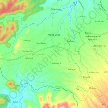
Name: Magallanes topographic map, elevation, terrain.

Location: Magallanes, Cavite, Calabarzon, 4113, Philippines (14.12263 120.70076 14.21448 120.80899)

Average elevation: 198 m

Minimum elevation: 48 m

Maximum elevation: 517 m

Gear up for your next adventure:

🦶Hiking Shoe Insoles - Added support for high arches and long days on feet
🥾Mountain Hiking Shoes - Shoes with superior grip for mountainous terrain
🔋Solar Power Bank - Keep your GPS and devices charged during long outdoor trips
🔥Emergency Fire Starter - Reliable ignition source for all weather conditions
💧Hydration Bladder - Hands-free hydration solution for long treks

As an Amazon Associate, this site earns from qualifying purchases at no extra cost to you.