Geolocate

Lahaina topographic map

Click on the map to display elevation.

About this map

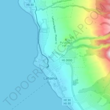
Name: Lahaina topographic map, elevation, terrain.

Location: Lahaina, Maui County, Hawaii, United States (20.85558 -156.69490 20.91834 -156.65032)

Average elevation: 84 m

Minimum elevation: -2 m

Maximum elevation: 504 m

Other topographic maps

Click on a map to view its topography, its elevation and its terrain.

Haleakalā

United States > Hawaii > Maui County

Average elevation: 2,085 m

Gear up for your next adventure:

🥾Mountain Hiking Boots - High-traction boots for rocky terrain
📷Outdoor Action Camera - Capture high-elevation views and rugged adventures
🔭Outdoor Binoculars - Lightweight binoculars for birdwatching and hiking
🎒Backpack Rain Cover - External shield to keep your entire pack dry
🥾Hiking Shorts - Breathable shorts suitable for summer hikes

As an Amazon Associate, this site earns from qualifying purchases at no extra cost to you.