
Make a donation
Gear up for your next adventure:
As an Amazon Associate, this site earns from qualifying purchases at no extra cost to you.
Semmering topographic map
Click on the map to display elevation.
Make a donation
Gear up for your next adventure:
As an Amazon Associate, this site earns from qualifying purchases at no extra cost to you.
Semmering
Semmering is located on the border of Lower Austria and Styria at an elevation of 1,000 m (3,280 ft) above sea level and surrounded with forest. Semmering city is located in Neunkirchen, about 100 km (60 mi) from Vienna.
Make a donation
Gear up for your next adventure:
As an Amazon Associate, this site earns from qualifying purchases at no extra cost to you.
About this map
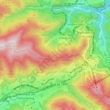
Name: Semmering topographic map, elevation, terrain.
Location: Semmering, Bezirk Neunkirchen, Lower Austria, 2680, Austria (47.61810 15.78132 47.65734 15.85002)
Average elevation: 1,001 m
Minimum elevation: 653 m
Maximum elevation: 1,401 m
Make a donation
Gear up for your next adventure:
As an Amazon Associate, this site earns from qualifying purchases at no extra cost to you.
Other topographic maps
Click on a map to view its topography, its elevation and its terrain.
Wechsel
Austria > Lower Austria > Bezirk Neunkirchen > Mönichkirchen > Pfeffergraben
The Wechsel Pass (elevation 980 m, 3,215 ft) is a mountain pass in the Austrian Alps, located between the Bundesländer of Lower Austria and Styria.
Average elevation: 906 m
Klosterwappen
Austria > Lower Austria > Bezirk Neunkirchen > Gemeinde Reichenau an der Rax
A rack-and-pinion railway, the Schneeberg Railway, now over 100 years old, climbs to a height of 1,800 m (5,900 ft), reducing the walk to the summit to an hour or two. There are also a number of other routes for walkers, including from the spa resort of Puchberg am Schneeberg to the east, or from the south, in…
Average elevation: 1,715 m
Sonnleiten
Austria > Lower Austria > Bezirk Neunkirchen > Gemeinde Schwarzau im Gebirge
Average elevation: 872 m
Make a donation
Gear up for your next adventure:
As an Amazon Associate, this site earns from qualifying purchases at no extra cost to you.