Geolocate

Roura topographic map

Click on the map to display elevation.

About this map
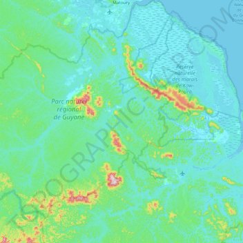
Name: Roura topographic map, elevation, terrain.

Location: Roura, Cayenne, French Guiana, France (4.09529 -52.85748 4.85674 -52.16282)

Average elevation: 48 m

Minimum elevation: -3 m

Maximum elevation: 468 m

Other topographic maps

Click on a map to view its topography, its elevation and its terrain.

Fedi

France > French Guiana > Apatou

Average elevation: 31 m

Saint Joseph Island

France > French Guiana > Cayenne

Average elevation: 1 m

Devil's Island

France > French Guiana > Cayenne

Average elevation: 1 m

Crique Paracou

France > French Guiana > Sinnamary

Average elevation: 5 m

Tampok

France > French Guiana

Average elevation: 154 m

Lawa

France > French Guiana > Maripasoula

Average elevation: 110 m

Montagne d'Argent

France > French Guiana > Ouanary

Average elevation: 9 m

Dobai

France > French Guiana > Grand-Santi

Average elevation: 39 m

Lawa

France > French Guiana > Maripasoula

Average elevation: 110 m

Gear up for your next adventure:

⛺Lightweight Camping Tent - Portable shelter optimized for Canadian backcountry camping
⛺Lightweight Backpacking Tent - Compact tent for efficient hiking trips
🥾Light Hiking Boots - Lightweight and comfortable boots for day hikes
🥾Hiking Shoes - Durable and comfortable shoes for trail hiking
🧴Outdoor Sunscreen - High SPF protection for high-altitude UV exposure

As an Amazon Associate, this site earns from qualifying purchases at no extra cost to you.