Geolocate

Macra topographic map

Click on the map to display elevation.

About this map

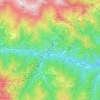
Name: Macra topographic map, elevation, terrain.

Location: Macra, Cuneo, Piedmont, Italy (44.46264 7.12421 44.54311 7.22001)

Average elevation: 1,413 m

Minimum elevation: 731 m

Maximum elevation: 2,501 m

Other topographic maps

Click on a map to view its topography, its elevation and its terrain.

Artic

Italy > Piedmont > Cuneo > Frabosa Soprana

Average elevation: 1,093 m

Gear up for your next adventure:

🛶Canoe Life Vest - Safety vest for water sports
🔋Solar Power Bank - Keep your GPS and devices charged during long outdoor trips
🛏️Sleeping Bag - Warm and compact sleeping bags for outdoor camping
🥾Waterproof Hiking Boots - Essential footwear for rugged terrain and wet Canadian trails
🚲Handlebar Phone Mount - View topographic-map.com live while cycling

As an Amazon Associate, this site earns from qualifying purchases at no extra cost to you.