Geolocate

Molina topographic map

Click on the map to display elevation.

About this map

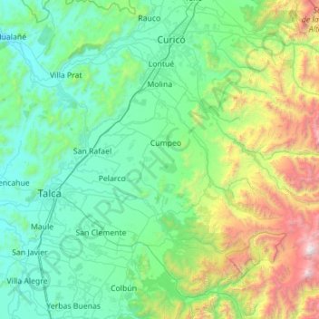
Name: Molina topographic map, elevation, terrain.

Location: Molina, Provincia de Curicó, Maule Region, Chile (-35.63041 -71.50302 -35.02725 -70.38652)

Average elevation: 669 m

Minimum elevation: 24 m

Maximum elevation: 3,940 m

Gear up for your next adventure:

🥾Trail Hiking Boots - Supportive boots for rough trails
🧦Hiking Liner Socks - Thin base layer to prevent friction and blisters
🥾Light Hiking Boots - Lightweight and comfortable boots for day hikes
🚑Survival Whistle - Signal for help across long distances in mountains
🧥Thermal Layer - Insulating layer for cold outdoor conditions

As an Amazon Associate, this site earns from qualifying purchases at no extra cost to you.