

Limeira topographic map
Click on the map to display elevation.
Limeira
Limeira is a city in the eastern part of the Brazilian state of São Paulo. With a population of approximately 291,869 people (2022 IBGE.) and covering an area of 581 square kilometers, it sits at an elevation of 588 meters. The city is situated 154 kilometers from São Paulo, the capital of the state, and 1011 kilometers from Brasilia, the capital of Brazil. Limeira is conveniently accessible from São Paulo via two highways: Rodovia Anhanguera and Rodovia dos Bandeirantes.
About this map
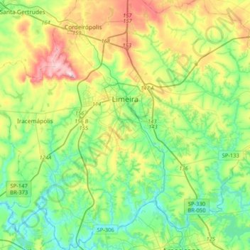
Name: Limeira topographic map, elevation, terrain.
Average elevation: 599 m
Minimum elevation: 494 m
Maximum elevation: 827 m
Other topographic maps
Click on a map to view its topography, its elevation and its terrain.
Mirante Rio Piracicaba
Brazil > São Paulo > Região Metropolitana de Piracicaba > Piracicaba
Average elevation: 505 m
Kobayat Líbano
Brazil > São Paulo > Região Metropolitana de Piracicaba > Piracicaba
Average elevation: 521 m

Nova Piracicaba
Brazil > São Paulo > Região Metropolitana de Piracicaba > Piracicaba
Average elevation: 493 m