Geolocate

Alcúdia topographic map

Click on the map to display elevation.

About this map

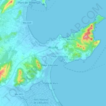
Name: Alcúdia topographic map, elevation, terrain.

Location: Alcúdia, Raiguer, Balearic Islands, Spain (39.79899 3.03563 39.89336 3.20450)

Average elevation: 20 m

Minimum elevation: -5 m

Maximum elevation: 424 m

Other topographic maps

Click on a map to view its topography, its elevation and its terrain.

es Pla de na Tesa

Spain > Balearic Islands > Raiguer > Marratxí

Average elevation: 40 m

Gear up for your next adventure:

🔭Compact Monocular - One-handed bird watching and trail spotting
🥾Waterproof Hiking Shoes - Durable shoes for wet and rugged trails
🥾Lightweight Hiking Shoes - Comfortable shoes for day hikes
🧥Thermal Fleece Jacket - Versatile insulation for changing mountain temperatures
🔦LED Headtorch - Bright and durable light for night activities

As an Amazon Associate, this site earns from qualifying purchases at no extra cost to you.