
Make a donation
Gear up for your next adventure:
As an Amazon Associate, this site earns from qualifying purchases at no extra cost to you.
Bulle topographic map
Click on the map to display elevation.
Make a donation
Gear up for your next adventure:
As an Amazon Associate, this site earns from qualifying purchases at no extra cost to you.
Bulle
The municipality is the capital of the Gruyère district. It is located on a hill at an elevation of 770 meters (2,530 ft) above the left side of the Trême river.
Make a donation
Gear up for your next adventure:
As an Amazon Associate, this site earns from qualifying purchases at no extra cost to you.
About this map
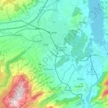
Name: Bulle topographic map, elevation, terrain.
Location: Bulle, Gruyère District, Fribourg, Switzerland (46.56952 6.99339 46.64054 7.09527)
Average elevation: 834 m
Minimum elevation: 665 m
Maximum elevation: 1,383 m
Make a donation
Gear up for your next adventure:
As an Amazon Associate, this site earns from qualifying purchases at no extra cost to you.