Geolocate

Juneau topographic map

Click on the map to display elevation.

About this map

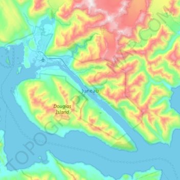
Name: Juneau topographic map, elevation, terrain.

Location: Juneau, Alaska, 99802, United States (58.14195 -134.57973 58.46195 -134.25973)

Average elevation: 374 m

Minimum elevation: -4 m

Maximum elevation: 1,660 m

Gear up for your next adventure:

🔋Emergency Crank Radio - Weather alerts and power without needing batteries
🔦LED Headlamp - Hands-free lighting for early morning starts or late finishes
🗺️Topographic Maps - Detailed maps to explore trails, mountains, and wilderness areas
🥾Waterproof Hiking Shoes - Durable shoes for wet and rugged trails
🔥Emergency Fire Starter - Reliable ignition source for all weather conditions

As an Amazon Associate, this site earns from qualifying purchases at no extra cost to you.