
Make a donation
Gear up for your next adventure:
As an Amazon Associate, this site earns from qualifying purchases at no extra cost to you.
Glan topographic map
Click on the map to display elevation.
Make a donation
Gear up for your next adventure:
As an Amazon Associate, this site earns from qualifying purchases at no extra cost to you.
About this map
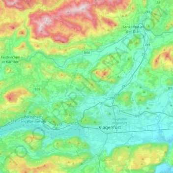
Name: Glan topographic map, elevation, terrain.
Location: Glan, Bezirk Feldkirchen, Carinthia, Austria (46.60312 14.05787 46.76334 14.42568)
Average elevation: 630 m
Minimum elevation: 398 m
Maximum elevation: 1,333 m
Make a donation
Gear up for your next adventure:
As an Amazon Associate, this site earns from qualifying purchases at no extra cost to you.
Other topographic maps
Click on a map to view its topography, its elevation and its terrain.
Turracher Höhe
Austria > Carinthia > Reichenau
The highest point of the approx. two km long pass summit has an altitude of 1,795 m above sea level south of the Turracher Lake. The lake has a water level of 1,763 m above sea (Adria) level and is connected to the village. The Turracher Höhe, as a "classic" pass summit, is also part of a drainage divide…
Average elevation: 1,870 m