Geolocate

Calderon topographic map

Click on the map to display elevation.

About this map

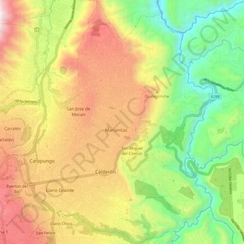
Name: Calderon topographic map, elevation, terrain.

Location: Calderon, Quito Canton, Pichincha, Ecuador (-0.13698 -78.46145 -0.02397 -78.37159)

Average elevation: 2,466 m

Minimum elevation: 1,816 m

Maximum elevation: 3,230 m

Other topographic maps

Click on a map to view its topography, its elevation and its terrain.

La Victoria

Ecuador > Pichincha > Quito Canton > Yaruquí

Average elevation: 2,530 m

San Miguel del Común

Ecuador > Pichincha > Quito Canton

Average elevation: 2,536 m

Calderón

Ecuador > Pichincha > Quito Canton

Average elevation: 2,542 m

Gear up for your next adventure:

🎒Fully Waterproof Backpack - Total protection for photography gear and electronics
💡Solar Camping Lamp - Eco-friendly lighting for campsites
🧤Rechargeable Heated Gloves - Extreme warmth for Canadian winter expeditions
🌬️Windproof Camp Stove - Efficient cooking even on exposed mountain peaks
💧Hydration Pack - Hands-free hydration system for long hikes

As an Amazon Associate, this site earns from qualifying purchases at no extra cost to you.