Geolocate

Darby topographic map

Click on the map to display elevation.

About this map

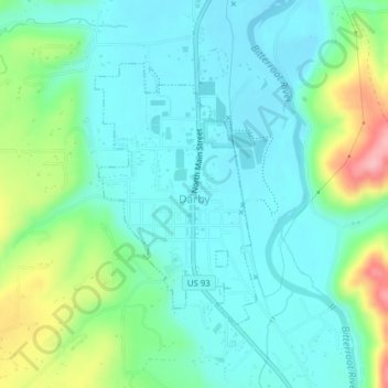
Name: Darby topographic map, elevation, terrain.

Location: Darby, Ravalli County, Montana, United States (46.01387 -114.18807 46.03207 -114.17181)

Average elevation: 1,210 m

Minimum elevation: 1,174 m

Maximum elevation: 1,316 m

Other topographic maps

Click on a map to view its topography, its elevation and its terrain.

Sky Pilot

United States > Montana > Ravalli County

Average elevation: 2,281 m

Gear up for your next adventure:

🧥Thermal Fleece Jacket - Versatile insulation for changing mountain temperatures
🥾Hiking Gaiters - Protect legs and shoes from mud, snow, and debris
🌬️Windproof Camp Stove - Efficient cooking even on exposed mountain peaks
🔦UV Flashlight - Detect minerals or specific insects in the dark
🔋Lithium AA Batteries - Long-lasting power that performs in extreme cold

As an Amazon Associate, this site earns from qualifying purchases at no extra cost to you.