
Thank you for supporting this site ❤️
Make a donation
Make a donation
Gear up for your next adventure:
As an Amazon Associate, this site earns from qualifying purchases at no extra cost to you.
Bhaironghati topographic map
Click on the map to display elevation.
Thank you for supporting this site ❤️
Make a donation
Make a donation
Gear up for your next adventure:
As an Amazon Associate, this site earns from qualifying purchases at no extra cost to you.
About this map
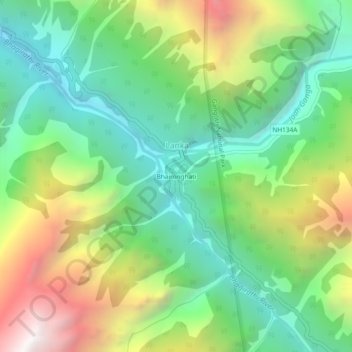
Name: Bhaironghati topographic map, elevation, terrain.
Location: Bhaironghati, Lanka, Bhatwari, Uttarkashi, India (31.00672 78.84788 31.04672 78.88788)
Average elevation: 3,227 m
Minimum elevation: 2,566 m
Maximum elevation: 4,400 m
Thank you for supporting this site ❤️
Make a donation
Make a donation
Gear up for your next adventure:
As an Amazon Associate, this site earns from qualifying purchases at no extra cost to you.