Geolocate

Ko Samui topographic map

Click on the map to display elevation.

About this map

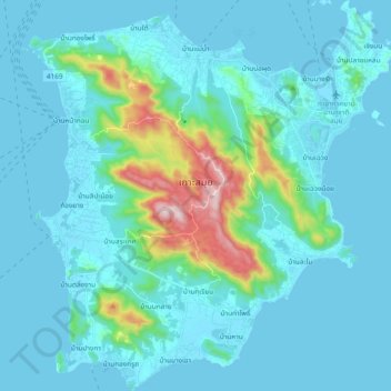
Name: Ko Samui topographic map, elevation, terrain.

Location: Ko Samui, Surat Thani Province, Thailand (9.40867 99.91211 9.59360 100.09061)

Average elevation: 75 m

Minimum elevation: -1 m

Maximum elevation: 621 m

Gear up for your next adventure:

🔦LED Headlamp - Hands-free lighting for early morning starts or late finishes
🔥Camping Stove - Portable stoves to cook outdoors with ease
🥾Waterproof Hiking Shoes - Durable shoes for wet and rugged trails
🎒Fully Waterproof Backpack - Total protection for photography gear and electronics
Lightweight Backpacking Tent - Compact tent for efficient hiking trips

As an Amazon Associate, this site earns from qualifying purchases at no extra cost to you.