
Make a donation
Gear up for your next adventure:
As an Amazon Associate, this site earns from qualifying purchases at no extra cost to you.
Departamento Guaymallén topographic map
Click on the map to display elevation.
Make a donation
Gear up for your next adventure:
As an Amazon Associate, this site earns from qualifying purchases at no extra cost to you.
About this map
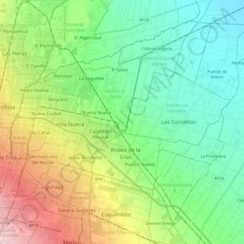
Name: Departamento Guaymallén topographic map, elevation, terrain.
Location: Departamento Guaymallén, Mendoza, Argentina (-32.97037 -68.83906 -32.82969 -68.63697)
Average elevation: 701 m
Minimum elevation: 624 m
Maximum elevation: 879 m
Make a donation
Gear up for your next adventure:
As an Amazon Associate, this site earns from qualifying purchases at no extra cost to you.
Other topographic maps
Click on a map to view its topography, its elevation and its terrain.
Maipo
Argentina > Mendoza > Distrito Pareditas
The region's climate is transitional between the drier Mediterranean climate of the peaks to the north and the cold, moist climate of Chilean Patagonia. Hence, while less glaciated than Patagonia, it has more permanent snow on the wet, Chilean side than peaks of similar elevation to the north.
Average elevation: 4,747 m