
Make a donation
Gear up for your next adventure:
As an Amazon Associate, this site earns from qualifying purchases at no extra cost to you.
Ribeirão Preto topographic map
Click on the map to display elevation.
Make a donation
Gear up for your next adventure:
As an Amazon Associate, this site earns from qualifying purchases at no extra cost to you.
Ribeirão Preto
Ribeirão Preto is the eighth-largest municipality in the State with 650.9 km2 (251.3 sq mi). It has an estimated population of 720,216 in 2021 and a metropolitan area of 1,178,910. It is located 313 km (194 mi) from the city of São Paulo and 706 km (439 mi) from Brasília, the federal capital. Its mean altitude is 526.8 m (1,728 ft) high. The city's average temperature throughout the year is 23 °C (73 °F), and the original predominant vegetation is the Atlantic Forest.
Make a donation
Gear up for your next adventure:
As an Amazon Associate, this site earns from qualifying purchases at no extra cost to you.
About this map
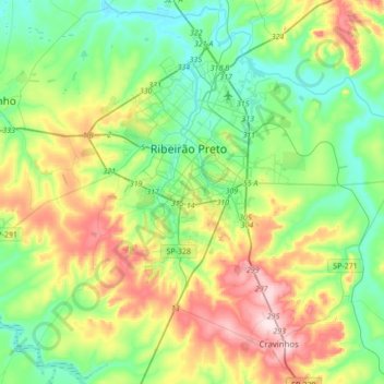
Name: Ribeirão Preto topographic map, elevation, terrain.
Average elevation: 612 m
Minimum elevation: 497 m
Maximum elevation: 851 m
Make a donation
Gear up for your next adventure:
As an Amazon Associate, this site earns from qualifying purchases at no extra cost to you.