
Make a donation
Gear up for your next adventure:
As an Amazon Associate, this site earns from qualifying purchases at no extra cost to you.
Viladecans topographic map
Click on the map to display elevation.
Make a donation
Gear up for your next adventure:
As an Amazon Associate, this site earns from qualifying purchases at no extra cost to you.
About this map
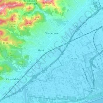
Name: Viladecans topographic map, elevation, terrain.
Location: Viladecans, Baix Llobregat, Barcelona, Catalonia, 08840, Spain (41.27031 1.98811 41.33810 2.07481)
Average elevation: 36 m
Minimum elevation: -1 m
Maximum elevation: 282 m
Make a donation
Gear up for your next adventure:
As an Amazon Associate, this site earns from qualifying purchases at no extra cost to you.
Other topographic maps
Click on a map to view its topography, its elevation and its terrain.
Parc Forestal de l'Ermita del Pla de Sant Joan
Spain > Catalonia > Baix Llobregat > la Palma de Cervelló > Urbanització Can Vidal
Average elevation: 127 m
Make a donation
Gear up for your next adventure:
As an Amazon Associate, this site earns from qualifying purchases at no extra cost to you.
Piug de Miramar
Spain > Catalonia > Baix Llobregat > Sant Climent de Llobregat
Average elevation: 100 m
Molins de Rei
Spain > Catalonia > Baix Llobregat > Molins de Rei > Molins de Rei
Average elevation: 117 m