Geolocate

Fontgombault topographic map

Click on the map to display elevation.

About this map
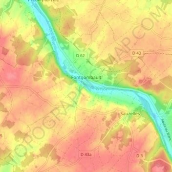
Name: Fontgombault topographic map, elevation, terrain.

Location: Fontgombault, Le Blanc, Indre, Centre-Val de Loire, Metropolitan France, 36220, France (46.65045 0.93884 46.69296 1.01066)

Average elevation: 112 m

Minimum elevation: 68 m

Maximum elevation: 137 m

Other topographic maps

Click on a map to view its topography, its elevation and its terrain.

Le Fragne

France > Centre-Val de Loire > Indre > Sarzay

Average elevation: 224 m

Fein

France > Centre-Val de Loire > Indre > Nohant-Vic

Average elevation: 198 m

Larage

France > Centre-Val de Loire > Indre > Migné > Chézal Fragné

Average elevation: 119 m

Grandchamp

France > Centre-Val de Loire > Indre > Pérassay

Average elevation: 334 m

Nuissance

France > Centre-Val de Loire > Indre > Levroux

Average elevation: 161 m

Nuissance

France > Centre-Val de Loire > Indre > Levroux

Average elevation: 161 m

L'Amoureux

France > Centre-Val de Loire > Indre > Champillet

Average elevation: 276 m

Éguzon

France > Centre-Val de Loire > Indre > Éguzon-Chantôme

Average elevation: 255 m

Les Arènes

France > Centre-Val de Loire > Indre > Levroux

Average elevation: 151 m

Avail

France > Centre-Val de Loire > Indre > Issoudun

Average elevation: 153 m

Les Marigouts

France > Centre-Val de Loire > Indre > Clion

Average elevation: 137 m

Charneuil

France > Centre-Val de Loire > Indre > Mauvières

Average elevation: 115 m

Gear up for your next adventure:

👟Trail Running Shoes - Agile footwear for fast-paced topographic exploration
🦶Anti-Blister Balm - Prevents friction and hotspots during long ascents
🔭Compact Monocular - One-handed bird watching and trail spotting
🥤Collapsible Travel Cup - Saves space and weight in your mess kit
🥾Waterproof Hiking Boots - Boots keeping your feet dry in wet conditions

As an Amazon Associate, this site earns from qualifying purchases at no extra cost to you.