Geolocate

Fairbury topographic map

Click on the map to display elevation.

About this map

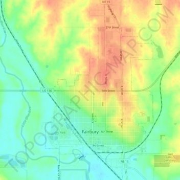
Name: Fairbury topographic map, elevation, terrain.

Location: Fairbury, Jefferson County, Nebraska, United States (40.12618 -97.19404 40.16718 -97.16184)

Average elevation: 417 m

Minimum elevation: 394 m

Maximum elevation: 443 m

Gear up for your next adventure:

🧢Sun Hat - Wide-brim hat for sun protection
Lightweight Backpacking Tent - Compact tent for efficient hiking trips
🥾Light Trekking Boots - Supportive boots for multi-day treks
🛶Canoe Life Vest - Safety vest for water sports
🧥Waterproof Jacket - Lightweight rain jackets for hiking and outdoor activities

As an Amazon Associate, this site earns from qualifying purchases at no extra cost to you.