
Troyes topographic map
Interactive map
Click on the map to display elevation.
About this map
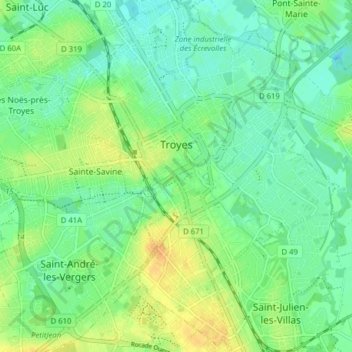
Name: Troyes topographic map, elevation, terrain.
Location: Troyes, Aube, Grand Est, Metropolitan France, 10000, France (48.26632 4.04117 48.31859 4.11114)
Average elevation: 112 m
Minimum elevation: 100 m
Maximum elevation: 132 m
Other topographic maps
Click on a map to view its topography, its elevation and its terrain.
Parc de Songis
France > Grand Est > Aube > Troyes
Parc de Songis, Troyes, Aube, Grand Est, Metropolitan France, 10000, France
Average elevation: 110 m
Lac d'Orient
France > Grand Est > Aube > Mesnil-Saint-Père
Lac d'Orient, Mesnil-Saint-Père, Troyes, Aube, Grand Est, Metropolitan France, 10140, France
Average elevation: 140 m
Saint-Hyppolite
France > Grand Est > Aube > La Rivière-de-Corps
Saint-Hyppolite, La Rivière-de-Corps, Troyes, Aube, Grand Est, Metropolitan France, 10440, France
Average elevation: 124 m