Geolocate

Soto del Real topographic map

Click on the map to display elevation.

About this map

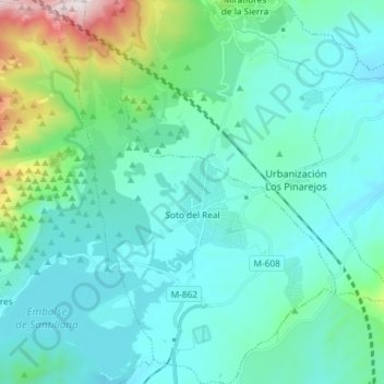
Name: Soto del Real topographic map, elevation, terrain.

Location: Soto del Real, Community of Madrid, 28791, Spain (40.70448 -3.83956 40.81518 -3.73201)

Average elevation: 1,056 m

Minimum elevation: 861 m

Maximum elevation: 2,111 m

Other topographic maps

Click on a map to view its topography, its elevation and its terrain.

Madrid

Spain > Community of Madrid > Madrid

Average elevation: 650 m

Fuente Pila

Spain > Community of Madrid > Navalcarnero

Average elevation: 631 m

Eurovillas

Spain > Community of Madrid > Eurovillas

Average elevation: 826 m

Montecillo

Spain > Community of Madrid > Las Vegas > Villaconejos

Average elevation: 677 m

Gear up for your next adventure:

🛶Kayak Dry Bag - Waterproof storage for kayaking adventures
🔦LED Headlamp - Hands-free lighting for early morning starts or late finishes
🧼Travel Hand Sanitizer - Keep hands clean when water is scarce
🧤Thermal Hiking Gloves - Grip-enhanced gloves for cold-weather altitude trekking
💧Collapsible Water Bottle - Space-saving water bottle for outdoor activities

As an Amazon Associate, this site earns from qualifying purchases at no extra cost to you.