Geolocate

Cerceda topographic map

Click on the map to display elevation.

About this map
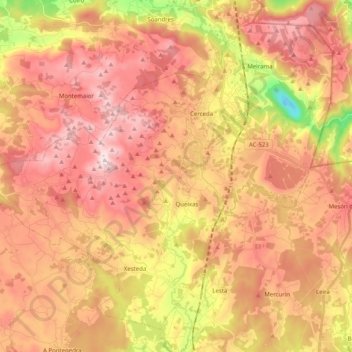
Name: Cerceda topographic map, elevation, terrain.

Location: Cerceda, Ordes, A Coruña, Galicia, Spain (43.09889 -8.59686 43.22652 -8.39606)

Average elevation: 364 m

Minimum elevation: 19 m

Maximum elevation: 591 m

Other topographic maps

Click on a map to view its topography, its elevation and its terrain.

Hospital

Spain > Galicia > Ordes

Average elevation: 404 m

O Canedo

Spain > Galicia > Ordes

Average elevation: 376 m

Cruz de Nouche

Spain > Galicia > Ordes > Beán

Average elevation: 312 m

Meitufe do Medio

Spain > Galicia > Ordes > Ordes

Average elevation: 383 m

Gear up for your next adventure:

🧢Sun Protection Cap - Breathable cap to protect from sun exposure
🌡️Emergency Mylar Blankets - Compact thermal protection for unexpected nights outdoors
🚲Handlebar Phone Mount - View topographic-map.com live while cycling
🧥Ultralight Puffy Jacket - Maximum warmth that packs down to the size of an orange
🥾Trekking Poles - Adjustable trekking poles to reduce knee stress and improve stability

As an Amazon Associate, this site earns from qualifying purchases at no extra cost to you.