
Lansing topographic map
Click on the map to display elevation.
About this map
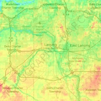
Name: Lansing topographic map, elevation, terrain.
Location: Lansing, Ingham County, Michigan, United States (42.64748 -84.70128 42.79498 -84.41758)
Average elevation: 263 m
Minimum elevation: 238 m
Maximum elevation: 294 m
Other topographic maps
Click on a map to view its topography, its elevation and its terrain.
Burchfield Park
United States > Michigan > Ingham County > Delhi Charter Township
Average elevation: 268 m
Village of Dansville Community Park
United States > Michigan > Ingham County > Dansville
Average elevation: 289 m