
Make a donation
Gear up for your next adventure:
As an Amazon Associate, this site earns from qualifying purchases at no extra cost to you.
Chur topographic map
Click on the map to display elevation.
Make a donation
Gear up for your next adventure:
As an Amazon Associate, this site earns from qualifying purchases at no extra cost to you.
Chur
The altitude in the city area varies from 600 meters (2,000 ft) above sea level to 1,800 meters (5,900 ft) above sea level, the Churer Hausberg Brambrüesch (accessible from the Old Town) situated at 2,174 meters (7,133 ft) above sea level.
Make a donation
Gear up for your next adventure:
As an Amazon Associate, this site earns from qualifying purchases at no extra cost to you.
About this map
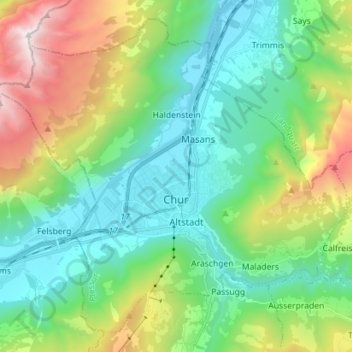
Name: Chur topographic map, elevation, terrain.
Location: Chur, Plessur, Grisons, Switzerland (46.81803 9.45411 46.90424 9.59524)
Average elevation: 1,177 m
Minimum elevation: 535 m
Maximum elevation: 2,792 m
Make a donation
Gear up for your next adventure:
As an Amazon Associate, this site earns from qualifying purchases at no extra cost to you.