Geolocate

Lincoln City topographic map

Click on the map to display elevation.

About this map
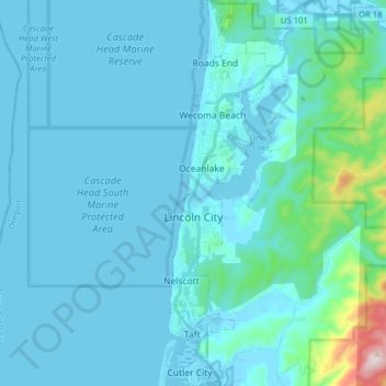
Name: Lincoln City topographic map, elevation, terrain.

Location: Lincoln City, Lincoln County, Oregon, 97367, United States (44.91319 -124.02620 45.02426 -123.97798)

Average elevation: 47 m

Minimum elevation: -1 m

Maximum elevation: 556 m

Other topographic maps

Click on a map to view its topography, its elevation and its terrain.
Otter Rock

United States > Oregon > Lincoln County

Average elevation: 6 m

Logsden

United States > Oregon > Lincoln County

Average elevation: 119 m

Tidewater

United States > Oregon > Lincoln County

Average elevation: 222 m

Seal Rock

United States > Oregon > Lincoln County

Average elevation: 6 m

Bayshore

United States > Oregon > Lincoln County

Average elevation: 15 m

Beverly Beach

United States > Oregon > Lincoln County

Average elevation: 29 m

Tidewater

United States > Oregon > Lincoln County

Average elevation: 222 m

Eddyville

United States > Oregon > Lincoln County

Average elevation: 131 m

Agate Beach

United States > Oregon > Lincoln County > Newport

Average elevation: 42 m

Logsden

United States > Oregon > Lincoln County

Average elevation: 119 m

Gear up for your next adventure:

⛺Tent Footprint - Protect tent floor and increase durability
💡LED Camping Lantern - Illuminate your campsite with long-lasting lanterns
🔦LED Flashlight - Powerful and long-lasting flashlight for camping and emergencies
🧦Crew Hiking Socks - Comfortable socks for long-distance hikes
💧Collapsible Water Bottle - Space-saving water bottle for outdoor activities

As an Amazon Associate, this site earns from qualifying purchases at no extra cost to you.