Geolocate

Ankara topographic map

Click on the map to display elevation.

Ankara

Ankara has a cold semi-arid climate (Köppen climate classification: BSk). Under the Trewartha climate classification, Ankara has a temperate humid continental climate (Dc). Due to its elevation and inland location, Ankara has cold and snowy winters, and hot and dry summers. Rainfall occurs mostly during the spring and autumn. The city lies in USDA Hardiness zone 7b, and its annual average precipitation is fairly low at 414 millimeters (16 in), nevertheless precipitation can be observed throughout the year. Monthly mean temperatures range from 0.9 °C (33.6 °F) in January to 24.3 °C (75.7 °F) in July, with an annual mean of 12.6 °C (54.7 °F).

Wikipedia (CC-BY-SA 3.0)

About this map

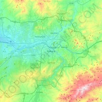
Name: Ankara topographic map, elevation, terrain.

Location: Ankara, Çankaya, Ankara, Central Anatolia Region, 06420, Turkey (39.76078 32.69405 40.08078 33.01405)

Average elevation: 1,082 m

Minimum elevation: 798 m

Maximum elevation: 1,864 m

Other topographic maps

Click on a map to view its topography, its elevation and its terrain.

Ahlatlıbel Mahallesi

Turkey > Çankaya

Average elevation: 1,144 m

Gaziosmanpaşa Mahallesi

Turkey > Çankaya

Average elevation: 986 m

100. Yıl Mahallesi

Turkey > Çankaya

Average elevation: 972 m

Kavaklıdere Mahallesi

Turkey > Çankaya

Average elevation: 918 m

Çayyolu Mahallesi

Turkey > Çankaya

Average elevation: 921 m

Koru Mahallesi

Turkey > Çankaya

Average elevation: 900 m

Gear up for your next adventure:

🥾Trail Hiking Boots - Supportive boots for rough trails
🥾Light Hiking Boots - Lightweight and comfortable boots for day hikes
🧭Orienteering Kit - Tools for map reading and navigation in the wild
Tent Footprint - Protect tent floor and increase durability
🥾Hiking Boots - Sturdy boots providing ankle support and traction on rugged trails

As an Amazon Associate, this site earns from qualifying purchases at no extra cost to you.