Cartersville topographic map
Interactive map
Click on the map to display elevation.
About this map
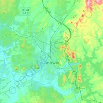
Name: Cartersville topographic map, elevation, terrain.
Location: Cartersville, Bartow County, Georgia, 30120, United States (34.08243 -84.86588 34.29379 -84.73650)
Average elevation: 260 m
Minimum elevation: 195 m
Maximum elevation: 531 m
Other topographic maps
Click on a map to view its topography, its elevation and its terrain.
Rydal
United States > Georgia > Bartow County
Rydal, Bartow County, Georgia, 30171, United States
Average elevation: 273 m
Emerson
United States > Georgia > Bartow County
Emerson, Bartow County, Georgia, 30137, United States
Average elevation: 254 m
Taylorsville
United States > Georgia > Bartow County
Taylorsville, Bartow County, Georgia, United States
Average elevation: 227 m
White
United States > Georgia > Bartow County
White, Bartow County, Georgia, United States
Average elevation: 271 m
Euharlee
United States > Georgia > Bartow County
Euharlee, Bartow County, Georgia, United States
Average elevation: 215 m
Red Top Mountain State Park
United States > Georgia > Bartow County
Red Top Mountain State Park, Bartow County, Georgia, United States
Average elevation: 276 m
Adairsville
United States > Georgia > Bartow County
Adairsville, Bartow County, Georgia, 30103, United States
Average elevation: 254 m
Weiss Lake
United States > Georgia > Bartow County > Cartersville
Weiss Lake, Cartersville, Bartow County, Georgia, United States
Average elevation: 276 m
Emerson
United States > Georgia > Bartow County > Emerson
Emerson, Bartow County, Georgia, 30137, United States
Average elevation: 266 m
Kingston
United States > Georgia > Bartow County
Kingston, Bartow County, Georgia, United States
Average elevation: 223 m