
Make a donation
Gear up for your next adventure:
As an Amazon Associate, this site earns from qualifying purchases at no extra cost to you.
Châteaudun topographic map
Click on the map to display elevation.
Make a donation
Gear up for your next adventure:
As an Amazon Associate, this site earns from qualifying purchases at no extra cost to you.
About this map
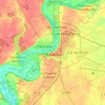
Name: Châteaudun topographic map, elevation, terrain.
Average elevation: 131 m
Minimum elevation: 97 m
Maximum elevation: 157 m
Make a donation
Gear up for your next adventure:
As an Amazon Associate, this site earns from qualifying purchases at no extra cost to you.
Other topographic maps
Click on a map to view its topography, its elevation and its terrain.
Villarceaux
France > Centre-Val de Loire > Eure-et-Loir > Les Villages Vovéens
Average elevation: 151 m
Make a donation
Gear up for your next adventure:
As an Amazon Associate, this site earns from qualifying purchases at no extra cost to you.
Chartres Cathedral
France > Centre-Val de Loire > Eure-et-Loir > Chartres
The elevation of the nave, showing the gallery on the ground level; the narrow triforium; and, on top, the windows of the clerestory
Average elevation: 148 m
Domaine des Evis
France > Centre-Val de Loire > Eure-et-Loir > La Chapelle-Fortin
Average elevation: 220 m