Geolocate

Lahad Datu topographic map

Click on the map to display elevation.

About this map

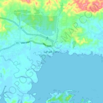
Name: Lahad Datu topographic map, elevation, terrain.

Location: Lahad Datu, Sabah, 91110, Malaysia (4.98157 118.28755 5.06157 118.36755)

Average elevation: 17 m

Minimum elevation: -1 m

Maximum elevation: 117 m

Other topographic maps

Click on a map to view its topography, its elevation and its terrain.

Mabul Island

Malaysia > Sabah

Average elevation: 0 m

Gear up for your next adventure:

🥾All-Terrain Hiking Boots - Versatile boots for varied hiking conditions
🥾Mountain Trail Shoes - High-traction shoes for mountain trails
Lightweight Camping Tent - Portable shelter optimized for Canadian backcountry camping
💧Filtered Water Bottle - Safe drinking water on the go
🥾Trekking Boots - Durable boots for long-distance trekking

As an Amazon Associate, this site earns from qualifying purchases at no extra cost to you.