Geolocate

Fladungen topographic map

Click on the map to display elevation.

About this map

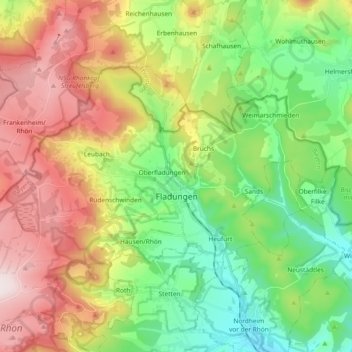
Name: Fladungen topographic map, elevation, terrain.

Location: Fladungen, Fladungen (VGem), Landkreis Rhön-Grabfeld, Bavaria, 97650, Germany (50.49090 10.03886 50.56471 10.22494)

Average elevation: 544 m

Minimum elevation: 318 m

Maximum elevation: 878 m

Other topographic maps

Click on a map to view its topography, its elevation and its terrain.

Gear up for your next adventure:

🧴Sunscreen SPF - Broad-spectrum sunscreen for outdoor activities
👟Sport Hiking Sandals - Breathable footwear for water crossings and camp rest
🕶️Polarized Sunglasses - Reduces glare from snow and water at high elevations
🧢Outdoor Visor - Breathable visor for sunny hikes
🔦LED Flashlight - Powerful and long-lasting flashlight for camping and emergencies

As an Amazon Associate, this site earns from qualifying purchases at no extra cost to you.