
Make a donation
Gear up for your next adventure:
As an Amazon Associate, this site earns from qualifying purchases at no extra cost to you.
Parnaíba topographic map
Click on the map to display elevation.
Make a donation
Gear up for your next adventure:
As an Amazon Associate, this site earns from qualifying purchases at no extra cost to you.
Parnaíba
Parnaíba is located at Parnaíba River basin and is cut by that which divides into several arms forming the famous Delta of the only offshore of the Americas and the third largest in the world, second only to the Nile in Egypt and Mekong in Southeast Asia. One of these arms is the "river" Igaraçu where the port is located from barcase. Most of the city is on the right bank of the Igaraçu since the rest is in Big Island of Santa Isabel, now in Parnaíba River delta. The only beach of the city is the Pedra do Sal, ideal for surfing, kite surfing and wind surfing. Another source is the city Portinho Lagoon, one of the most famous tourist attractions, that due to the advance of the dunes may disappear. The city is located on land Cenozoic Quaternary and has altitude of about 5 meters in areas of the urban center which is away from the coast. It lies on the coastal plain and the topography is fairly regular. Mangrove vegetation and scrub predominates in the creeks and on river banks, coca crops in the rest of the territory. Megathermal semi-humid tropical climate predominates in the region, with high rate of rainfall due to the mass action Equatorial Atlantic during the months from January to June.
Make a donation
Gear up for your next adventure:
As an Amazon Associate, this site earns from qualifying purchases at no extra cost to you.
About this map
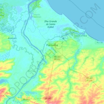
Name: Parnaíba topographic map, elevation, terrain.
Average elevation: 15 m
Minimum elevation: -2 m
Maximum elevation: 75 m
Make a donation
Gear up for your next adventure:
As an Amazon Associate, this site earns from qualifying purchases at no extra cost to you.
Other topographic maps
Click on a map to view its topography, its elevation and its terrain.
Beco da Raposa
Brazil > Piauí > Região Integrada de Desenvolvimento da Grande Teresina > Teresina
Average elevation: 143 m
Make a donation
Gear up for your next adventure:
As an Amazon Associate, this site earns from qualifying purchases at no extra cost to you.
Make a donation
Gear up for your next adventure:
As an Amazon Associate, this site earns from qualifying purchases at no extra cost to you.