Geolocate

Norfork topographic map

Click on the map to display elevation.

About this map

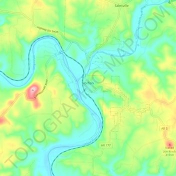
Name: Norfork topographic map, elevation, terrain.

Location: Norfork, Baxter County, Arkansas, 72658, United States (36.18305 -92.34966 36.23137 -92.24903)

Average elevation: 183 m

Minimum elevation: 102 m

Maximum elevation: 362 m

Gear up for your next adventure:

🏕️Camping Hammock - Integrated protection for sleeping between trees
🧥Waterproof Hiking Jacket - Protect yourself from rain and wind while hiking
🥾Mountain Hiking Shoes - Shoes with superior grip for mountainous terrain
🌬️Windproof Camp Stove - Efficient cooking even on exposed mountain peaks
🥾Trail Hiking Boots - Supportive boots for rough trails

As an Amazon Associate, this site earns from qualifying purchases at no extra cost to you.