Geolocate

Xinyang City topographic map

Click on the map to display elevation.

About this map

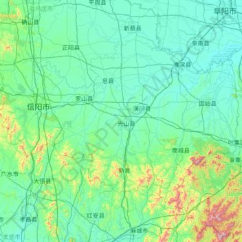
Name: Xinyang City topographic map, elevation, terrain.

Location: Xinyang City, Henan, China (31.38446 113.70346 32.66377 115.93862)

Average elevation: 143 m

Minimum elevation: 20 m

Maximum elevation: 1,679 m

Other topographic maps

Click on a map to view its topography, its elevation and its terrain.

Kaifeng

China > Henan > Gulou District > Xiangguosi Subdistrict

Average elevation: 75 m

Xinyang

China > Henan > Qianjin Subdistrict

Average elevation: 105 m

Daxingnanjiecun

China > Henan > Tangyin County

Average elevation: 85 m

Changtai

China > Henan

Average elevation: 84 m

Gear up for your next adventure:

🔪Outdoor Multitool - Versatile tool for repairs and food prep in the wild
🌬️Windproof Camp Stove - Efficient cooking even on exposed mountain peaks
🥾Mountain Trail Shoes - High-traction shoes for mountain trails
Camping Tent - Weather-resistant tents suitable for 2 to 6 people
🔨Vehicle Emergency Tool - Safety tool for remote road trips to trailheads

As an Amazon Associate, this site earns from qualifying purchases at no extra cost to you.