Geolocate

A Pontenova topographic map

Click on the map to display elevation.

A Pontenova

The Turia River (250 m altitude) gives its name to the valley. The Turia Valley is surrounded by hills and mountains, including, Sierra de Piedafita (900 m), Sierra de Ouroso (1033 m), Sierras de Dendin (900 m), Sierra de Teixedais (900 m) and Sierra de Eirua (700 m).

Wikipedia (CC-BY-SA 3.0)

About this map

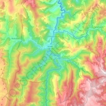
Name: A Pontenova topographic map, elevation, terrain.

Location: A Pontenova, A Mariña Oriental, Lugo, Galicia, Spain (43.25563 -7.26437 43.39631 -7.08816)

Average elevation: 430 m

Minimum elevation: 52 m

Maximum elevation: 940 m

Other topographic maps

Click on a map to view its topography, its elevation and its terrain.

O Carballo

Spain > Galicia > A Mariña Oriental > San Cosme

Average elevation: 79 m

As Brañas

Spain > Galicia > A Mariña Oriental

Average elevation: 20 m

Gear up for your next adventure:

🧥Waterproof Jacket - Lightweight rain jackets for hiking and outdoor activities
🧰Multitool Knife - Compact and versatile tool for outdoor use
🕯️Camping Lantern - Illuminates your entire campsite with high-efficiency LEDs
🥾Trekking Poles - Adjustable trekking poles to reduce knee stress and improve stability
📷Outdoor Action Camera - Capture high-elevation views and rugged adventures

As an Amazon Associate, this site earns from qualifying purchases at no extra cost to you.