
Make a donation
Gear up for your next adventure:
As an Amazon Associate, this site earns from qualifying purchases at no extra cost to you.
Cottonwood topographic map
Click on the map to display elevation.
Make a donation
Gear up for your next adventure:
As an Amazon Associate, this site earns from qualifying purchases at no extra cost to you.
About this map
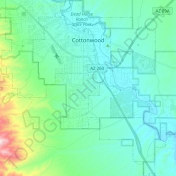
Name: Cottonwood topographic map, elevation, terrain.
Location: Cottonwood, Yavapai County, Arizona, 86236, United States (34.65068 -112.05372 34.76554 -111.94872)
Average elevation: 1,118 m
Minimum elevation: 969 m
Maximum elevation: 1,836 m
Make a donation
Gear up for your next adventure:
As an Amazon Associate, this site earns from qualifying purchases at no extra cost to you.
Other topographic maps
Click on a map to view its topography, its elevation and its terrain.
Chino Valley
United States > Arizona > Yavapai County
The town is in north-central Arizona, on state Highway 89, 15 miles (24 km) north of Prescott and 35 miles (56 km) south of Ash Fork, which is on Interstate 40. Chino Valley is at an elevation of about 4,750 feet (1,450 m).
Average elevation: 1,454 m