Geolocate

Pattaya topographic map

Click on the map to display elevation.

About this map

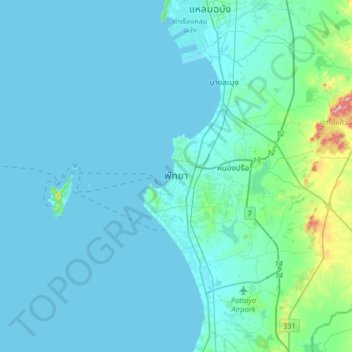
Name: Pattaya topographic map, elevation, terrain.

Location: Pattaya, Nong Pla Lai, Chon Buri Province, 20210, Thailand (12.77667 100.72646 13.09667 101.04646)

Average elevation: 28 m

Minimum elevation: -1 m

Maximum elevation: 337 m

Gear up for your next adventure:

🧭GPS Tracker - Track your location in remote areas safely
🦯Trekking Poles - Reduced impact on joints for steep topographic climbs
🦶Hiking Shoe Insoles - Added support for high arches and long days on feet
🧢Beanie Hat - Keep your head warm in cold weather
🎒Hiking Backpack - Lightweight and ergonomic backpacks for day hikes or multi-day treks

As an Amazon Associate, this site earns from qualifying purchases at no extra cost to you.