Geolocate

Njoro topographic map

Click on the map to display elevation.

About this map

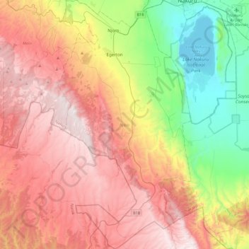
Name: Njoro topographic map, elevation, terrain.

Location: Njoro, Nakuru, Rift Valley, 20106, Kenya (-0.71296 35.84496 -0.27968 36.07754)

Average elevation: 2,413 m

Minimum elevation: 1,754 m

Maximum elevation: 3,071 m

Other topographic maps

Click on a map to view its topography, its elevation and its terrain.

Kenya

Kenya > Nakuru > Nakuru East > Nakuru East ward

Average elevation: 1,831 m

Wild Fire

Kenya > Nakuru > Naivasha > Hells Gate ward > Junction 1

Average elevation: 1,952 m

Fire

Kenya > Nakuru

Average elevation: 1,832 m

Mai Maihu

Kenya > Nakuru

Average elevation: 1,868 m

Gear up for your next adventure:

🧥Ultralight Puffy Jacket - Maximum warmth that packs down to the size of an orange
🧴Bear Spray Holster - Quick-access carry for essential Canadian wilderness safety
🧰Survival Kit - Essential gear for emergencies in the wilderness
🧰Emergency Multi-Tool - Compact multi-tool for outdoor survival
🧢Outdoor Visor - Breathable visor for sunny hikes

As an Amazon Associate, this site earns from qualifying purchases at no extra cost to you.