Geolocate

Sherwood topographic map

Click on the map to display elevation.

About this map

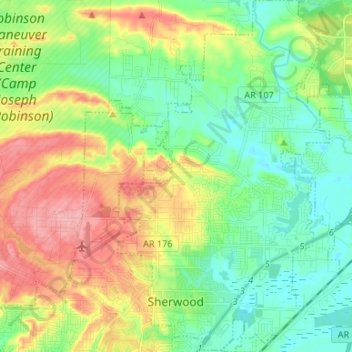
Name: Sherwood topographic map, elevation, terrain.

Location: Sherwood, Pulaski County, Arkansas, 72120, United States (34.79949 -92.24622 34.90834 -92.16135)

Average elevation: 108 m

Minimum elevation: 67 m

Maximum elevation: 178 m

Other topographic maps

Click on a map to view its topography, its elevation and its terrain.

Maumelle

United States > Arkansas > Pulaski County > Maumelle > Maumelle

Average elevation: 88 m

Gear up for your next adventure:

Camping Groundsheet - Protect your tent from moisture and dirt
🎒Hiking Backpack - Lightweight and ergonomic backpacks for day hikes or multi-day treks
Lightweight Camping Tent - Portable shelter optimized for Canadian backcountry camping
💧Hydration Bladder - Hands-free hydration solution for long treks
🥫Freeze-Dried Meals - Lightweight, high-calorie nutrition for multi-day treks

As an Amazon Associate, this site earns from qualifying purchases at no extra cost to you.