Geolocate

Bloomfield Hills topographic map

Click on the map to display elevation.

About this map

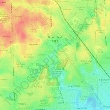
Name: Bloomfield Hills topographic map, elevation, terrain.

Location: Bloomfield Hills, Oakland County, Michigan, 48304, United States (42.55919 -83.26587 42.59695 -83.22539)

Average elevation: 261 m

Minimum elevation: 230 m

Maximum elevation: 292 m

Other topographic maps

Click on a map to view its topography, its elevation and its terrain.

Greens Lake

United States > Michigan > Oakland County

Average elevation: 309 m

Rossman Lake

United States > Michigan > Oakland County

Average elevation: 314 m

Gear up for your next adventure:

🥾Waterproof Hiking Shoes - Durable shoes for wet and rugged trails
🛌Down Sleeping Bag - Superior warmth-to-weight ratio for cold nights
🧴Sunscreen SPF - Broad-spectrum sunscreen for outdoor activities
🪑Insulated Seat Pad - Protect your seat from cold rocks and wet logs
👖Convertible Hiking Pants - Zip-off legs to adapt to changing weather conditions

As an Amazon Associate, this site earns from qualifying purchases at no extra cost to you.