
Make a donation
Gear up for your next adventure:
As an Amazon Associate, this site earns from qualifying purchases at no extra cost to you.
Mahbubnagar topographic map
Click on the map to display elevation.
Make a donation
Gear up for your next adventure:
As an Amazon Associate, this site earns from qualifying purchases at no extra cost to you.
Mahbubnagar
Mahbub Nagar is located at 16°44′N 77°59′E / 16.73°N 77.98°E / 16.73; 77.98. It has an average elevation of 498 metres (1633 feet). The city of Mahbub Nagar is located at a distance of 98 km from Hyderabad 130 km from Kurnool and 105 km from Raichur.
Make a donation
Gear up for your next adventure:
As an Amazon Associate, this site earns from qualifying purchases at no extra cost to you.
About this map
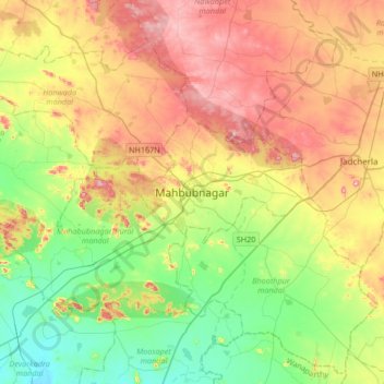
Name: Mahbubnagar topographic map, elevation, terrain.
Average elevation: 509 m
Minimum elevation: 373 m
Maximum elevation: 700 m
Make a donation
Gear up for your next adventure:
As an Amazon Associate, this site earns from qualifying purchases at no extra cost to you.