
Baia Mare topographic map
Interactive map
Click on the map to display elevation.
Baia Mare
The city is situated in the vicinity of the Gutâi and Igniș Mountains. Altitudes reach 1400 meters in some peaks. The area is famous for its outstanding landscapes, and the mountains are easily accessible from the city, famous routes being: Igniș (1307 m), Mogoșa (1246 m), Gutâi (1443 m), Creasta Cocoșului (1450 m), Piatra Soimului (839 m), Plestioara (803 m), Dealul Bulat (683 m), Murgau (633 m), Dealul Crucii (500 m) etc.
About this map
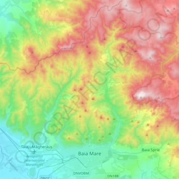
Name: Baia Mare topographic map, elevation, terrain.
Location: Baia Mare, Maramureș, Romania (47.62274 23.48205 47.85881 23.71164)
Average elevation: 592 m
Minimum elevation: 145 m
Maximum elevation: 1,306 m
Other topographic maps
Click on a map to view its topography, its elevation and its terrain.