
Badrinath topographic map
Click on the map to display elevation.
About this map
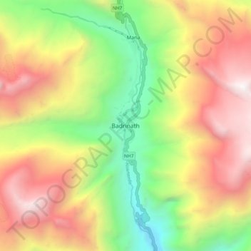
Name: Badrinath topographic map, elevation, terrain.
Location: Badrinath, Joshimath Tehsil, Chamoli, Uttarakhand, India (30.70233 79.45303 30.78233 79.53303)
Average elevation: 4,052 m
Minimum elevation: 2,685 m
Maximum elevation: 5,540 m
Other topographic maps
Click on a map to view its topography, its elevation and its terrain.
Valley of Flowers National Park
India > Uttarakhand > Joshimath Tehsil > Ghangaria
Average elevation: 4,606 m
Valley of Flowers National Park
India > Uttarakhand > Joshimath Tehsil > Ghangaria
Average elevation: 4,606 m